Today I received a donation that put my fundraising over the $5,000 mark! Thank you, thank you to all of my wonderful donors who have contributed so generously to my hike, particularly those who continue to sponsor me year after year. Your support means so much to me, and I couldn’t do these events and raise money for the Leukemia & Lymphoma Society without you. Some statistics, for those who like statistics:
Funds raised to date: $5,180
Total number of donors: 50
Average donation: $103.60
% of donations made online: 88%
Average online donation: $102.95
I also received some exciting news last night – our team of 23 people who will be hiking in Rocky Mountain National Park this weekend has raised over $140,000 this season! This is absolutely incredible. We are hoping to raise at least $150,000 by the end of June. The deadline for donations has been extended to June 20th. If you haven’t already made a donation, but still want to contribute, there is still time!
My online fundraising site is: http://www.active.com/donate/hfdnca04/mayalarson
Or you can send me a check in the mail to my home address.
I leave for Estes Park, Colorado on Saturday. I don’t know if I’ll have access to email while I’m there, but I hope to send out a note when I finish my hike. Wish me luck!
Wednesday, June 4, 2008

Saturday, May 31, 2008
What Happens When You Oversleep...
Our group hike today took place at White Oak Canyon in Shenandoah National Park, a steep hike with views of beautiful waterfalls. I, unfortunately, didn’t make it because I completely overslept. I had set my alarm for 5:30am, and in fact, set TWO alarms and didn't hear either of them. I subsequently missed two phone calls from my carpool at 6:15 and 6:30 wondering where I was. I didn't hear or feel the phone ring, and it was on my bed, six inches from my head. Guess I must have been really tired...
So when I finally woke up at 9:00, I had an "oh crap!" moment (except I don't think I used the word "crap"). Once I figured out what happened, I realized I still needed to get one more training hike in before my big trip. I called my buddy Patrick who agreed to hike the Billy Goat Trail at Great Falls with me. We started out around 11:15, and the weather was okay -- overcast but very humid. We made it to the steep part of the rock scramble before it started to rain. I took a few pictures before I had to put my camera away. Check out my photos here.
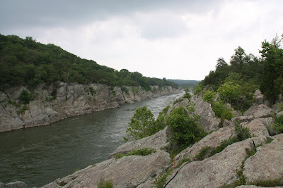
It let up a little bit until we stopped to eat along the river around 12:30. In the meantime, my friends Scott and Julie had called to say that they would meet us on the trail, coming from the opposite direction. We had just finished our snack when suddenly the sky opened up and it started to really come down. There was thunder and lightning, so we got the heck off the rocks and headed into the shaded trail. After a few minutes of hiking, we crossed a small runoff stream. I hopped across and landed on a rock with all my weight on my left foot, which slid down off the slick rock. I pitched forward and caught myself with my hands -- otherwise I would have come down hard on my right knee and probably banged it up pretty badly. Fortunately, I walked away with only a scratch.
A few minutes later, I was talking to Patrick as we rounded a corner and I heard someone say, “Yeah, that’s Maya.” Julie and Scott were crouched beneath an overhanging rock, waiting for us and trying to avoid the pelting rain. Apparently my voice carries, even in the wet woods. So the four of us made our way back to the trailhead and the towpath and the rain died down. While on the towpath, we saw all kinds of animals -- water snakes, turtles, huge fish, deer, and blue herons. We even spotted an owl just off the trail. It was making hooting noises while sitting in a tree, then it took off and flew through the woods. I didn't think I could get my camera out in time, so I just stood there and enjoyed watching the beautiful bird.
We made it halfway down the 1.5-mile towpath when it began to POUR. It wasn’t SO bad until the lightning strikes got closer and closer. We sought shelter under a wooden bridge with some other hikers to wait out the lightning. Of course, with the cold wind blowing and water drizzling off the bridge, we didn’t exactly stay dry or warm. After about 10 minutes or so, we decided just to head for the parking lot, about .4 miles away. Needless to say, we were completely soaked by the time we finished. One thing I learned is that waterproof boots, when worn in a rainstorm, make really good buckets!
So special thanks to Scott and Julie who will probably never hike with me again (at least, not without foul weather gear) and to Patrick, who has hiked with me under worse conditions. :) After hiking Old Rag last week, the rock scramble on the Billy Goat Trail was a piece of cake. I have one more week before the Rockies – I think I’m ready!!
So when I finally woke up at 9:00, I had an "oh crap!" moment (except I don't think I used the word "crap"). Once I figured out what happened, I realized I still needed to get one more training hike in before my big trip. I called my buddy Patrick who agreed to hike the Billy Goat Trail at Great Falls with me. We started out around 11:15, and the weather was okay -- overcast but very humid. We made it to the steep part of the rock scramble before it started to rain. I took a few pictures before I had to put my camera away. Check out my photos here.
It let up a little bit until we stopped to eat along the river around 12:30. In the meantime, my friends Scott and Julie had called to say that they would meet us on the trail, coming from the opposite direction. We had just finished our snack when suddenly the sky opened up and it started to really come down. There was thunder and lightning, so we got the heck off the rocks and headed into the shaded trail. After a few minutes of hiking, we crossed a small runoff stream. I hopped across and landed on a rock with all my weight on my left foot, which slid down off the slick rock. I pitched forward and caught myself with my hands -- otherwise I would have come down hard on my right knee and probably banged it up pretty badly. Fortunately, I walked away with only a scratch.
A few minutes later, I was talking to Patrick as we rounded a corner and I heard someone say, “Yeah, that’s Maya.” Julie and Scott were crouched beneath an overhanging rock, waiting for us and trying to avoid the pelting rain. Apparently my voice carries, even in the wet woods. So the four of us made our way back to the trailhead and the towpath and the rain died down. While on the towpath, we saw all kinds of animals -- water snakes, turtles, huge fish, deer, and blue herons. We even spotted an owl just off the trail. It was making hooting noises while sitting in a tree, then it took off and flew through the woods. I didn't think I could get my camera out in time, so I just stood there and enjoyed watching the beautiful bird.
We made it halfway down the 1.5-mile towpath when it began to POUR. It wasn’t SO bad until the lightning strikes got closer and closer. We sought shelter under a wooden bridge with some other hikers to wait out the lightning. Of course, with the cold wind blowing and water drizzling off the bridge, we didn’t exactly stay dry or warm. After about 10 minutes or so, we decided just to head for the parking lot, about .4 miles away. Needless to say, we were completely soaked by the time we finished. One thing I learned is that waterproof boots, when worn in a rainstorm, make really good buckets!
So special thanks to Scott and Julie who will probably never hike with me again (at least, not without foul weather gear) and to Patrick, who has hiked with me under worse conditions. :) After hiking Old Rag last week, the rock scramble on the Billy Goat Trail was a piece of cake. I have one more week before the Rockies – I think I’m ready!!
Sunday, May 25, 2008
Return to Old Rag Mountain
It's Memorial Day weekend, so there was no organized hike this week. I decided to plan my own hike to Old Rag Mountain in Shenandoah National Park. Old Rag is described by most as a "strenuous" hike because it not only involves hiking straight up a mountain (with an elevation gain of about 2,500 ft over the course of 2 or 3 miles), but there is a rock scramble for the last mile before the summit, where you sometimes need to pull yourself up onto boulders and hop over wide crevices in the granite.
I made sure to take some experienced Old Raggers with me. All of us had hiked it at least 4 times before. Carey, Ellen and Shayna did Hike for Discovery with me in Yosemite 2 years ago, and Patrick has been my trusty hike buddy throughout 3 seasons now. I knew I could count on him to boost me up in places where I would need boosting... or at least make fun of me when I did something goofy (like rip the seam in the seat of my hiking pants -- yikes!). Here's a picture he took of me scrambling up a steep rock:
I made sure to take some experienced Old Raggers with me. All of us had hiked it at least 4 times before. Carey, Ellen and Shayna did Hike for Discovery with me in Yosemite 2 years ago, and Patrick has been my trusty hike buddy throughout 3 seasons now. I knew I could count on him to boost me up in places where I would need boosting... or at least make fun of me when I did something goofy (like rip the seam in the seat of my hiking pants -- yikes!). Here's a picture he took of me scrambling up a steep rock:

It was a beautiful day for hiking, though it quickly got warm when we were heading uphill. It was also a very popular day to be hiking -- I had never seen the parking lot that full before. A lot of people (couples, families, hike groups) passed us on the way up. (Of course, we passed them on the way down, but that's another story.) I just bought a new DSLR camera in preparation for my trip out west, but wanted to test it out (in terms of functionality and weight since it’s quite a bit heavier than my old point-and-shoot). I stopped a lot to take pictures of my fellow hikers, flowers and trees along the way.
It took us about 4 hours to get to the top, not including the break for lunch partway up and looking around at the summit, then about 2.5 hours to get back down the back side of the mountain and back to the parking lot. Here's a picture of the gang at the summit:

I feel like I am almost ready for the Rockies. Just 2 more weeks to go!!
Monday, May 19, 2008
Overall Run Trail and the Hill of Doom
Yesterday's hike took us on a 10-mile circuit on the Overall Run Trail, passing by Overall Run Falls, the tallest waterfall in Shenandoah National Park (at 93 feet). Now mind you, I didn't think this hike would take as long as it did, but I did not anticipate the amount of elevation change.
Our hike leader, Jon, who chooses our training trails said in the parking lot, "I've learned from Maya that there are 3 kinds of hills: 'I don't like Jon' hills, 'I hate Jon' hills, and 'I want to kill Jon' hills." Needless to say, we had all 3 varieties on this trek. (This has been a running joke for the 2 years I've known Jon -- he knows I love him dearly!)
We started at an elevation of 2900' and proceeded to hike down the trail into a canyon, and down some more. We actually kept going down for a couple of hours and then it hit us -- we're eventually going to have to get back up to the top! The good news for me as we were hiking down was that I practically run downhill (since gravity is working with me, I don't have much of a choice). The bad news was that most of my teammates have knee problems, so they have to take it much slower. Oh well, more time for me to stop and take pictures... It had also rained quite a bit the few days before, so all of our stream crossings proved to be somewhat challenging as the water was much higher than normal and it was difficult to find a way to cross without a) falling in, b) getting our boots soaked, or c) slipping on a wet rock. Oh, and did I mention that it was a bit chilly and sprinkling rain practically the whole time?
We made it as low as 900' before we started heading uphill. The first part wasn't so bad, but Jon keep warning us about the treacherous "Hill of Doom" that lay ahead. The return trip wasn't quite as long mileage-wise, but this one particular hill took us up 1 mile with 1200' feet of elevation gain. That's a pretty steep hill! I was doing fine until we got to the really really steep part:
Our hike leader, Jon, who chooses our training trails said in the parking lot, "I've learned from Maya that there are 3 kinds of hills: 'I don't like Jon' hills, 'I hate Jon' hills, and 'I want to kill Jon' hills." Needless to say, we had all 3 varieties on this trek. (This has been a running joke for the 2 years I've known Jon -- he knows I love him dearly!)
We started at an elevation of 2900' and proceeded to hike down the trail into a canyon, and down some more. We actually kept going down for a couple of hours and then it hit us -- we're eventually going to have to get back up to the top! The good news for me as we were hiking down was that I practically run downhill (since gravity is working with me, I don't have much of a choice). The bad news was that most of my teammates have knee problems, so they have to take it much slower. Oh well, more time for me to stop and take pictures... It had also rained quite a bit the few days before, so all of our stream crossings proved to be somewhat challenging as the water was much higher than normal and it was difficult to find a way to cross without a) falling in, b) getting our boots soaked, or c) slipping on a wet rock. Oh, and did I mention that it was a bit chilly and sprinkling rain practically the whole time?
We made it as low as 900' before we started heading uphill. The first part wasn't so bad, but Jon keep warning us about the treacherous "Hill of Doom" that lay ahead. The return trip wasn't quite as long mileage-wise, but this one particular hill took us up 1 mile with 1200' feet of elevation gain. That's a pretty steep hill! I was doing fine until we got to the really really steep part:

I had to stop periodically to catch my breath. It was the first time all hike season that I had experienced any asthma symptoms and I was not happy about it. But eventually, with all my whining and "why does Jon do this to us?" complaints, we came upon the beautiful waterfall and suddenly it was all worth it...

We eventually made it back up to 2900' -- hallelujah! Then it took us another 20 minutes to get to the end of the trail. After 10 miles and 8 hours of being on my feet, I could not wait to get back to my car and get my feet out of my rigid boots and into my comfy sandals. In the end, it was a tough hike (and my calves are still cursing Jon's name), but it was good preparation for our challenging trails in the Rocky Mountains. In fact, I think we have LESS elevation gain/loss there than we did here today. But at least I am READY!
Saturday, April 26, 2008
Sugarloaf Mountain Hike
It was a chilly and wet (but not soggy) day today. We met up at Sugarloaf Mountain near Comus, MD at 8:30am and set off on a hike up and down and around the mountain. Well, that's what it would have been had we not taken the wrong trail... We inadvertantly took a shortcut, so we doubled back and took another longer way around so that we could get in some decent mileage. As you can see from the photo, the trail was pretty foggy.

We had a fun crew, though, so it was a good time. My friend, Allie, joined us and got to meet some of my hike buddies. We eventually ran into another training group that had taken the correct trail (for the most part).

All in all, it was a pretty good day to be out hiking.
Friday, April 25, 2008
Hiking in the Galapagos Islands
 In mid-April I had a once-in-a-lifetime opportunity to take a 10-day trip to Ecuador and the Galapagos Islands. The trip began in Guayaquil, the largest city in Ecuador. Our tour group of 11 people did a half-day tour of the city. The following day, we flew to Baltra in the Galapagos (about 600 miles of the coast of Ecuador). There we were met by our wonderful Naturalist Guide who took us to the Nemo I, a catamaran that was to be our home-away-from-home for the next week.
 Over the course of 7 days, we visited 11 or so different islands, seeing all kinds of wildlife from blue-footed boobies and albatrosses to sea lions, penguins, and tortoises. I didn't do any long training hikes with my backpack and gear, however, we usually went on a couple of 2-hour hikes each day, plus snorkeling or swimming at least once. There was so much to do, I never had time to write in my trip journal. Hopefully this entry plus the photos will suffice.
If you have never thought about going to the Galapagos, think about it. If you've always wanted to go, DO IT. You will be amazed at everything you see and learn. Here a few photos from my "training" hikes south of the equator.
A blue-footed booby:

View from the top of Bartolome Island (where scenes from the movie "Master and Commander" with Russell Crowe were filmed). We had to hike up a flight of wooden steps for nearly an hour to get all the way up here:

Hiking on a trail of crushed coral on Sombrero Chino Island:

To see more of my trip photos, please visit my Flickr.com site.
Sunday, April 6, 2008
Training Hike #4 - Buck Ridge/Buck Hollow Loop
We were originally supposed to hike Little Devils Stairs in Shenandoah National Park, but unfortunately, the road to the trail was closed. The park authorities were conducting a search and rescure operation for a local man who was reported missing and whose car was found abandoned in the park, so they shut down access. Our hike leaders chose another trail in Shenandoah instead -- Buck Ridge/Buck Hollow Loop, a 5.8-mile loop starting on Skyline Drive.
The weather called for steady rain, but we lucked out yet again. It was overcast and breezy at the trailhead, but got warmer as we descended the steep trail. The first half of the trail led us down and down for almost 3 miles. It was so steep that in some parts, log stairs were added.
We reached the bottom and turned to go up the second half of the trail, which was just as steep as the one on the way down. This trail, however, criss-crossed over Buck Hollow, a peaceful stream, several times so we could heard the water rippling for most of the ascent. I had missed the last two training hikes because I had injured my lower back, so I was pretty out of shape. Fortunately, my 3 teammates were extremely patient and waited with me as I stopped periodically to catch my breath (and snap some photos). Here's a picture of them (Kathy, Amy and Darcie):

Click here to view the rest of my hike training photo album.
Subscribe to:
Posts (Atom)
